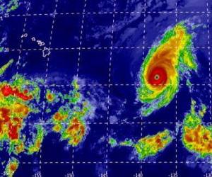
Two hurricanes are swirling in the Central Pacific and headed straight for the Hawaiian Islands. Hurricane Iselle and Hurricane Julio are on target to make landfall over the Big Island of Hawaii late Thursday night. As with any extreme weather, precautions are necessary and the threat of natural disaster is real.
Government officials for the state of Hawaii aren’t taking any chances and have closed all public schools on the Big Island as well as Maui County on Thursday in anticipation of the storms. Residents are heading to the stores where aisles have been cleared out of bottled water and food supplies as they hope for the best but prepare for the worst.
It’s a rare occurrence for a hurricane to hit the islands, let alone two. Iselle is currently a Category 1 hurricane and is expected to weaken as it approaches land. Julio was recently upgraded from a Tropical Storm to a Category 1 hurricane. It is expected to head just north of the islands and affect the islands on Sunday.
Anatomy of a Hurricane:
The Eye: Often referred to as the “The Eye of the Storm,” this area is typically free of clouds and consists of light winds. The air sinks and converges to create a warm, calm area at the center of the storm.
The Eye Wall: Surrounding the Eye is a wall of thunderstorms that produce heavy rain and high winds. This is the most destructive area of the storm.
Rain Bands: Spiraling out from the Eye Wall, Rain Bands form to create bursts of heavy rain and wind that are less destructive than that found in the Eye Wall.
What to Expect:
Storm Surge: Along the coast, the tide can rise up to 33 ft. and mow down anything in its path. Coastal areas are typically evacuated due to the strong impact it receives from the storm.
Tornados: Hurricanes often spawn tornadoes that can devastate homes, buildings, and other structures.
Floods: Flash floods caused by heavy rainfall and storm surge can wash out roads and evacuation routes.
High Winds: In a Category 1 hurricane, winds can reach up to 95 miles per hour. A Category 5, the most intense, can reach greater than 155 miles per hour. High winds can damage structures, as well as electrical wires, creating widespread power outages.
It’s important to be prepared and take necessary actions to remain safe during a storm. For the latest information on the storms, please visit the Central Pacific Hurricane Center.
For additional resources visit:
http://www.weather.com/weather/hurricanecentral/
http://earthobservatory.nasa.gov/Features/Hurricanes/hurricanes_2.php

